The Importance of Bathymetric Surveys in Port Development
Ports are the lifeblood of global trade, bustling gateways where land and sea converge. Their efficiency and safety are paramount to national economies. But beneath the surface of the busy shipping lanes and towering cranes lies a hidden, dynamic world: the seabed. This underwater topography dictates everything from a ship's safe passage to the stability of a billion-dollar quay wall. Understanding this environment is not just an option; it's a necessity.
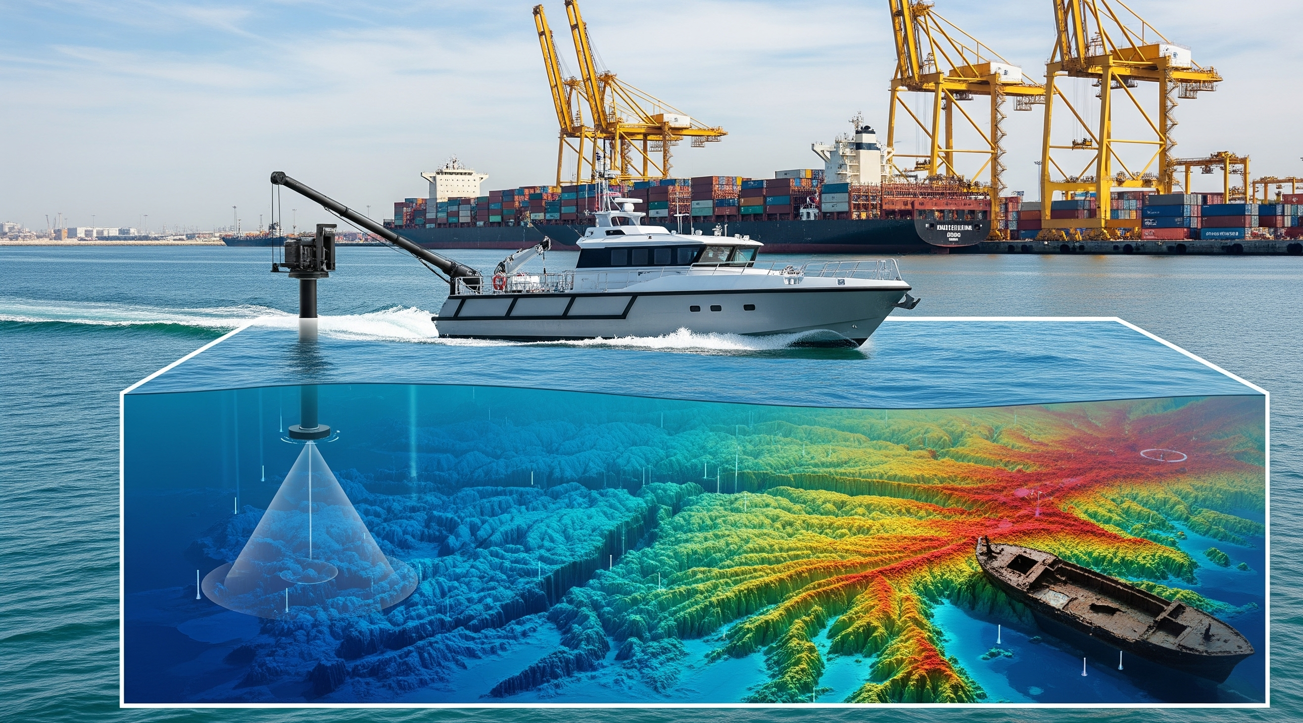
This is where bathymetric surveys come in. In essence, bathymetry is the science of measuring the depth of water bodies, creating the underwater equivalent of a topographic map. Using advanced technology like multi-beam echosounders, surveyors paint a detailed, three-dimensional picture of the seafloor. For any port authority, marine engineer, or coastal developer, this data is the foundational layer upon which safe, efficient, and sustainable port operations are built.
Here’s an in-depth look at how accurate depth maps are indispensable for modern port development.
1. Ensuring Safe Navigation and Channel Management
The most fundamental role of a port is to provide safe harbor for vessels. A ship's captain relies entirely on nautical charts for safe passage, and the accuracy of those charts is critical.
The Challenge: Underwater hazards like rock outcroppings, shipwrecks, and unseen shoals can lead to catastrophic grounding incidents. Furthermore, natural processes like siltation can gradually reduce the depth of navigation channels, making them unsafe for deep-draft vessels.
The Bathymetric Solution: A bathymetric survey provides precise water depth data across all channels and berths. It identifies the shallowest points (controlling depths) and pinpoints any potential obstructions. This information is used to create and update nautical charts, defining safe routes for vessel traffic and establishing the maximum allowable ship draft for the port. Regular surveys ensure these channels remain clear and safe year after year.
2. Optimizing Dredging Operations
To combat the natural buildup of sand and silt, most ports require regular dredging to maintain navigable depths. Dredging is a massive operational expense, and without accurate data, it can be incredibly inefficient.
The Challenge: Dredging without a precise map is like navigating in the dark. You can either dredge too little, failing to achieve the required depth and compromising safety, or dredge too much, wasting millions of dollars on unnecessary work and disposal.
The Bathymetric Solution: Pre-dredge surveys create a high-resolution map of the seabed, identifying exactly where sediment has accumulated and calculating the precise volume that needs to be removed. Post-dredge surveys are conducted after the work is complete to verify that the specified depths have been achieved across the entire area, providing quality assurance and a clear record of completion for contractors. This data-driven approach enables "precision dredging," ensuring that resources are focused only where they are needed, dramatically reducing costs and environmental impact.
3. Designing and Engineering Marine Structures
The construction of any marine infrastructure—from breakwaters and jetties to quay walls and underwater pipelines—depends entirely on a detailed understanding of the seabed.
The Challenge: Engineers cannot design stable and durable structures without knowing the exact shape, slope, and nature of the seafloor on which they will be built. A poor design based on inadequate data can lead to structural failure, enormous repair costs, and significant safety risks.
The Bathymetric Solution: Bathymetric data provides the essential 3D framework for engineering design. It allows engineers to determine the optimal location for structures, design stable foundations, plan construction methodologies, and accurately calculate the volume of materials required, such as rock for a breakwater.
4. Environmental Monitoring and Coastal Management
Port operations and coastal developments can have a significant impact on the surrounding marine environment. Monitoring these changes is crucial for sustainable management.
The Challenge: It is difficult to assess the long-term effects of erosion, sediment transport, or the impact of storms on the seabed without a baseline measurement.
The Bathymetric Solution: By conducting repeated surveys over months and years, a time-series of seabed maps can be created. This allows scientists and environmental managers to monitor changes, study the effects of coastal processes, and assess the environmental impact of port activities. This data is vital for coastal zone management plans and ensuring the long-term health of marine ecosystems.
A Foundation of Certainty
A high-quality bathymetric survey is more than just a map of the seafloor. It is a tool for risk mitigation, cost optimization, and intelligent design. It provides the certainty needed to operate a port safely, expand with confidence, and manage the marine environment responsibly. For any port authority, investing in accurate bathymetric data is a fundamental investment in its safety, efficiency, and future success.
Ready to leverage the power of bathymetric surveys?
Whether you are planning a new port development, optimizing dredging operations, or ensuring the safety of your navigation channels, accurate data is non-negotiable. Contact MEGA GEOSPATIAL to learn how our advanced hydrographic and bathymetric surveying services can provide the clarity you need to succeed.
Contact Us